How NaviSuite Kuda software enables Civil Tech Oy Ab to perform automated and remote surveys
‘Thanks to its automation tools and user-friendly, streamlined interface, NaviSuite Kuda Core is a great software solution for remote surveys. I have found that the Coverage Assist real-time runline creation tool steers the USV more accurately than a human would be able to, helping the surveyor to ensure efficient area coverage and high-quality data – overcoming challenges of shallow water conditions.’
Kasper Engblom
Technical expert at Civil Tech Oy Ab
How a remote, automated survey setup helps to efficiently and safely overcome challenging conditions
Imagine you’re surveying a shallow water area, where manned vessels can’t sail due to their size. Or you’re surveying an area that poses a risk to your team’s safety, such as around power plants.
These are among the scenarios in which Civil Tech finds it advantageous to perform surveys with USVs (unmanned surface vehicles) either operated from shore or over-the-horizon from the office by a remote surveyor.
Civil Tech is a Finnish company providing solutions for underwater surveys, planning and implementation since 2005. They have operated their USV for hundreds of operational hours with great success. The software they use for navigation, data acquisition and processing data from their USV is NaviSuite Kuda, EIVA’s hydrographic survey software.
In this case study, learn how Civil Tech uses NaviSuite Kuda Core to perform remote operations – as we dive into some of the surveys Civil Tech has performed, sharing details on...
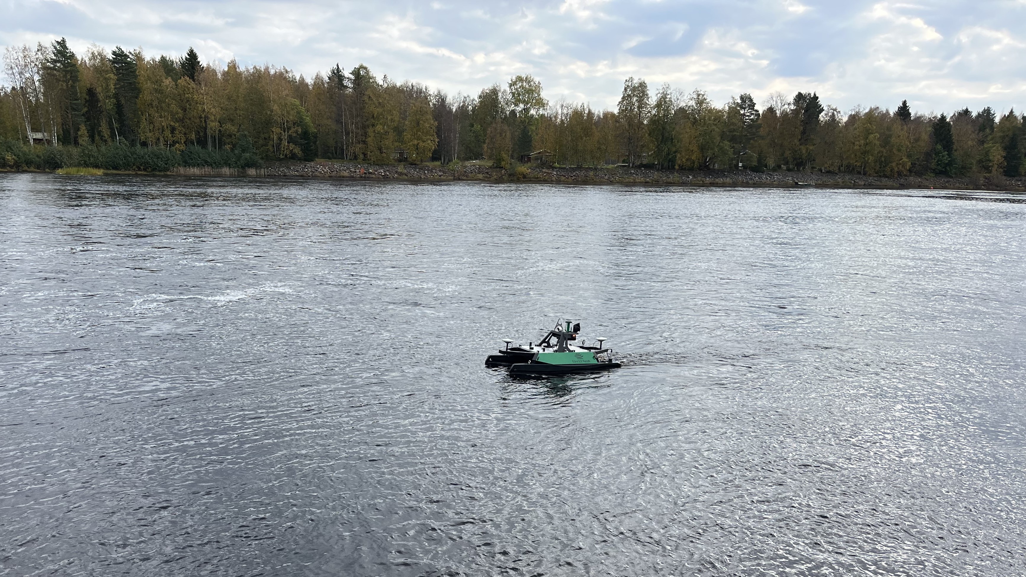
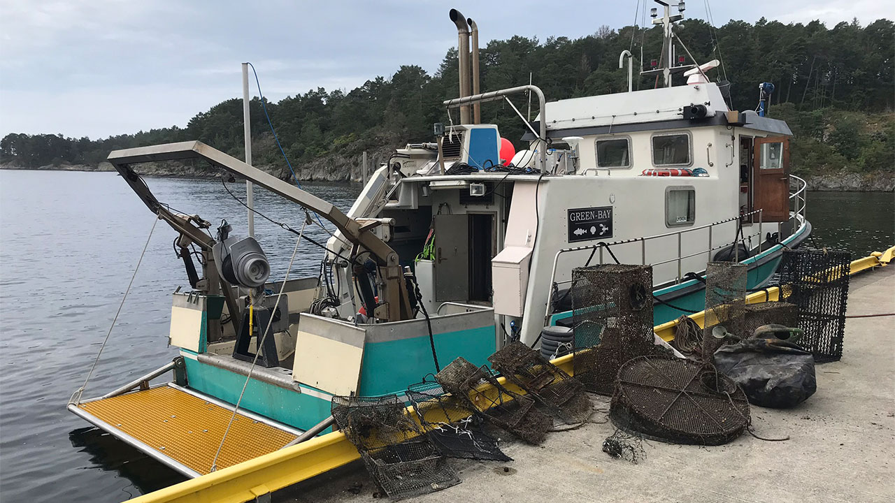
Civil Tech’s USV
Shallow water survey in Finland required USV operated from 700 km away
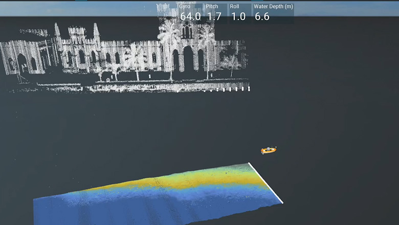
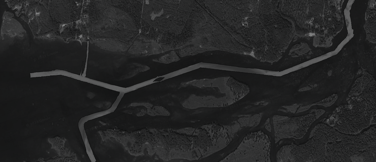
In the autumn of 2023, Civil Tech was doing a survey in Simo, Finland in an area with very shallow waters, including large areas with -1.1 m to -1.2 m depth, much of which was previously uncharted.
‘With such shallow water, we need to maintain as great a distance between the MBES and the seabed to obtain the greatest width of swath. This is why we used our lightweight USV, equipped with an R2Sonic MBES for scanning the seabed.’ Kasper Engblom, technical expert at Civil Tech, explains.
‘During this survey, I was tied up at Civil Tech HQ in Turku, Finland so I had to perform the survey from there, about 700 km from the survey site – but it doesn’t matter how far away I am, 500 km, 700 km, whatever, as long as there is a good 4G connection, it’s possible to perform the survey remotely with the help of a colleague deploying the USV.’
From his remote operation station, Kasper Engblom used NaviSuite Kuda tools for planning and navigating the survey, as well as acquiring and processing data.
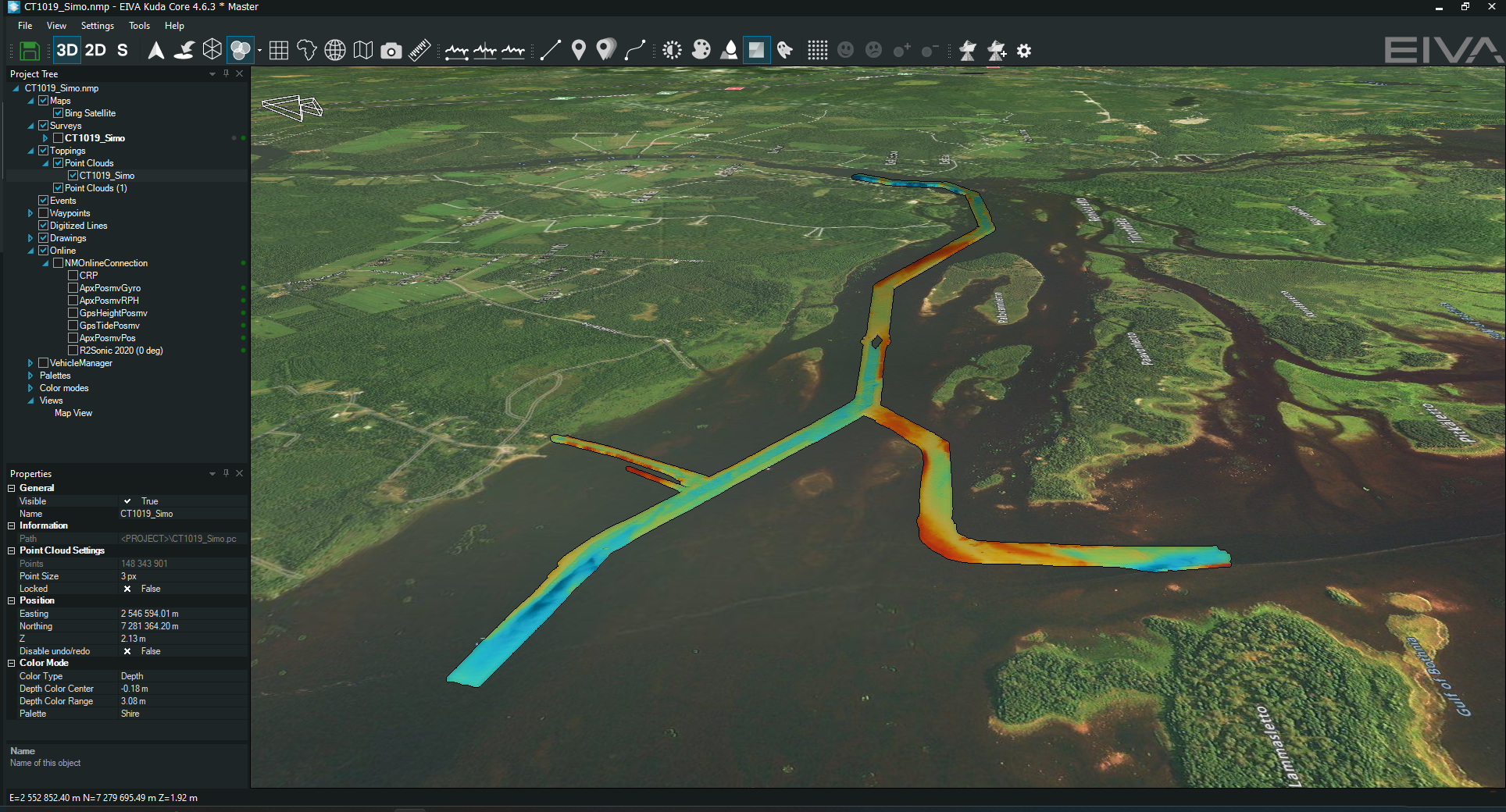
Resulting DTM (digital terrain model) from the Simo hydrographic survey
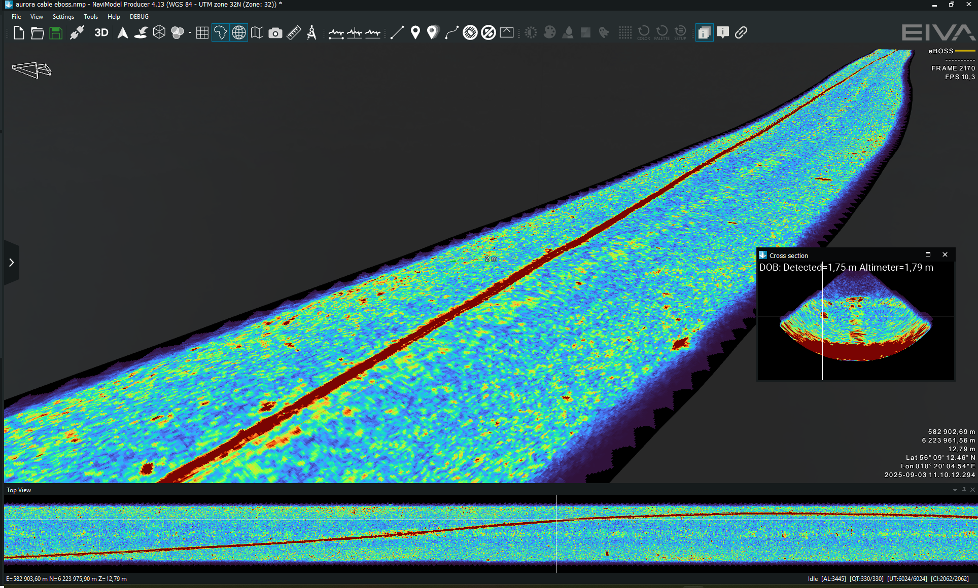
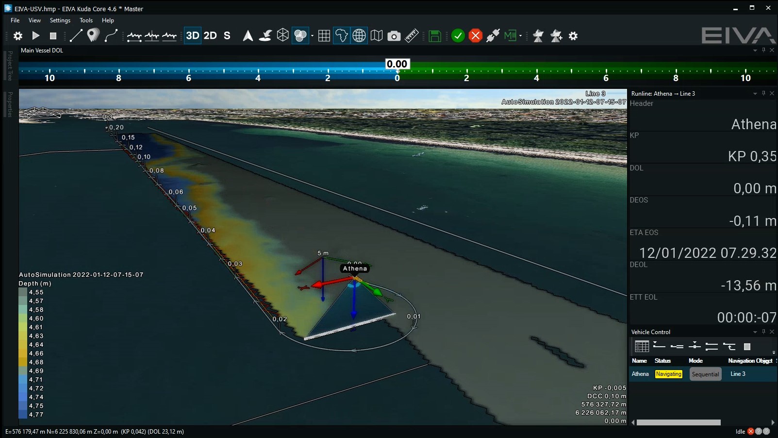
Coverage Assist software solution generates optimal runlines in real time
The Coverage Assist tool, which is a standard feature of the NaviSuite Kuda software, allows you to simply define the area you wish to survey, pre-adjust parameters as needed according to project specifications or complexity of the seabed… then press start and sit back while the software takes the wheel. The Coverage Assist tool plans each runline in real-time – taking into consideration the newly collected survey data to ensure full coverage.
‘I love using the Coverage Assist tool for automated runline planning – especially for surveys in shallow water. You see, in very shallow water, the multi-beam swath is so narrow that the efficiency of the survey is reduced significantly, and it becomes important to steer more precisely to avoid gaps and maximise coverage. Once the swath width shrinks to 3 m or less, you can’t afford to lose any of the swath to unnecessary overlap – or you will end up zigzagging back and forth over the same area without ever progressing. Coverage Assist steers the USV more accurately along the previous runline, helping us to overcome this challenge.’ Kasper Engblom.
One of the reasons the Coverage Assist tool is able to avoid gaps is that it automatically adjusts the route by registering any changes in heading, whether due to wave or weather. Plus, since it never tires or takes breaks, it is ideal for surveying large areas, as described in this case study on how this tool was custom developed in cooperation with Njord Survey (formerly Clinton).
See an example of the Coverage Assist tool in action
Coverage Assist use case: Icy waters call for optimised survey runlines
In addition to providing benefits in shallow waters, Kasper Engblom has found Coverage Assist helpful during USV surveys in challenging conditions where efficiency is key for completing the task…
‘Once, after arriving with our USV at the survey site, we found there was a thin layer of ice that had formed the night before. We rallied some local assistance and got the sheet of ice broken up and pushed away from the most critical areas of the survey. However, as the wind was continuously working against us, pushing the broken-up ice back onto the survey area, we had very limited time to get in some survey-lines. This forced us to prioritise the critical shallow areas which the customer wanted mapped.’ Kasper Engblom
Civil Tech therefore used Coverage Assist to cover as much of the critical area as possible, thereby achieving coverage in the most efficient way in the time available.

Coverage Assist in action during a survey conducted in the vicinity of Mariehamn, Åland

Photo showing the icy conditions during a remote hydrographic survey conducted by Civil Tech using NaviSuite Kuda’s Coverage Assist mode to survey the desired area optimally before the surface froze over again
Freeing up the surveyor results in improved data quality
‘Using Coverage Assist to automatically steer the USV along optimal runlines gives me more time to adjust parameters for data acquisition, so we get the highest possible quality results. When I’m controlling the USV manually on the other hand, I can’t easily make changes to the sonar data acquisition, because I’m busy navigating the vessel.’ Kasper Engblom
In addition to providing automation, NaviSuite Kuda software clears the way for Civil Tech surveyors to optimally perform operations through the intuitive and streamlined user interface.
‘Our survey team is typically two people, and sometimes there is not enough room on the computer screens to monitor and control all that we would like.’ Kasper Engblom.
To ensure that even setups with limited screen space can access the needed information in one application, the software variant NaviSuite Kuda Core has a streamlined interface tailored for USV and single-vessel surveys. Note that more complex survey setups requiring extra features are supported with a different tailored software variant, NaviSuite Kuda Pro.
‘With NaviSuite Kuda Core, there is only one application to set up instead of two, which saves both time and screen space – which is why we use this variant for our USV surveys.’ Kasper Engblom
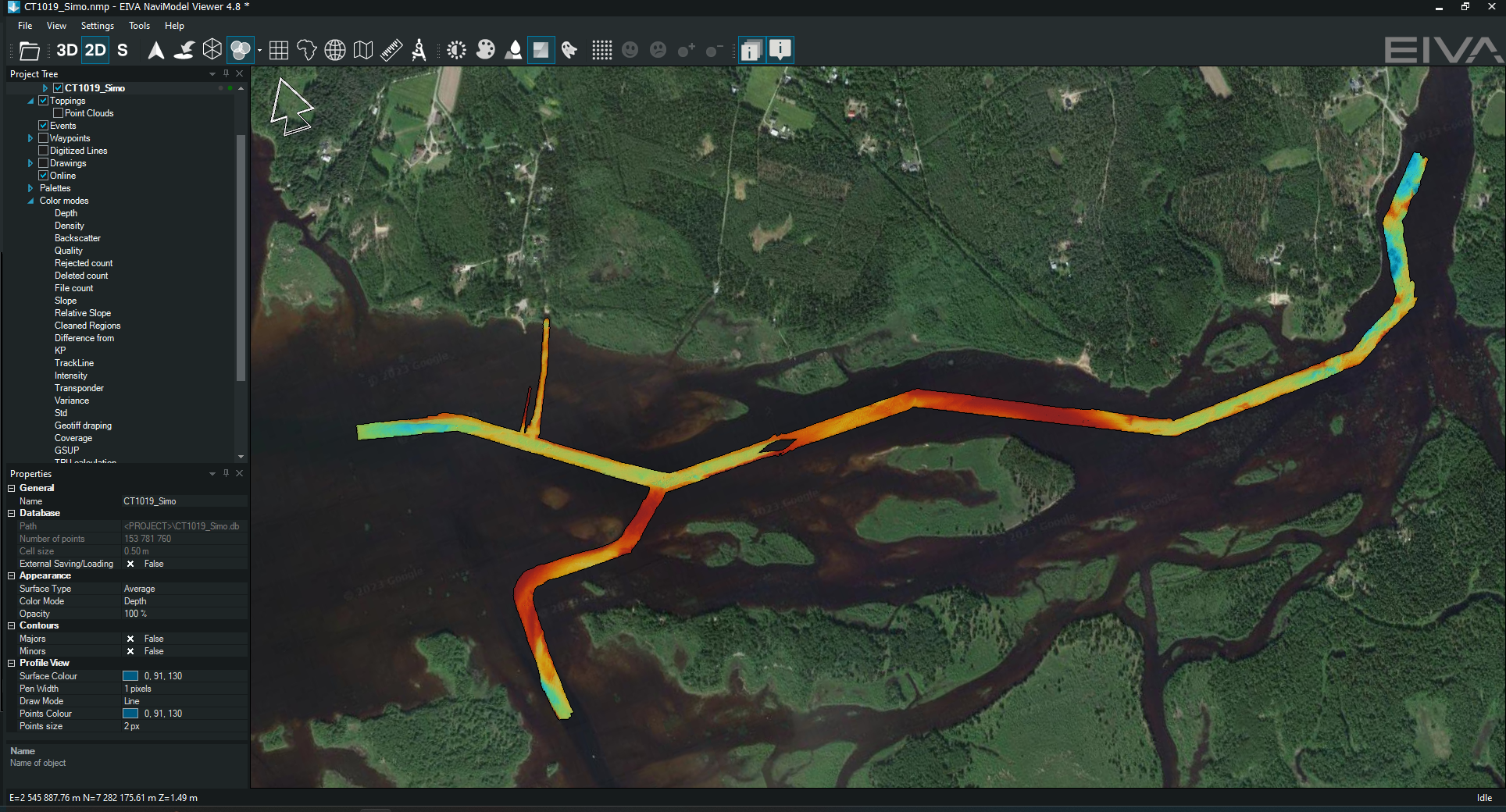
DTM results of Civil Tech’s survey in Simo, which Kasper operated from 700 km away, displayed in NaviModel Viewer
Not only screen space can be a limited resource, but also licences – which is why EIVA offers a free version of our visualisation software, NaviModel Viewer.
‘When all our processing software licenses are in use, but a project needs to be reviewed, checked or we need to make a screenshot, we can do those tasks with NaviModel Viewer. We also sometimes deliver projects to our customers with NaviModel Viewer software and a quick guide – so that they can navigate all data necessary for them on their own. This can for example be point clouds, DTMs and CAD drawings which we combined in the project.’ Kasper Engblom
Facts and figures
- As of December 2023, Civil Tech has used their USV with NaviSuite Kuda software for over 500 hours of survey operation time
- They also have used NaviSuite Mobula control and inspection software for their ROV
- They purchase permanent licences as well as daily subscriptions, as these options are tailored for different needs
- ‘In 2018, we started using NaviSuite software for our surveys. We learned to use it through a combination of the eLearning and training courses which EIVA offers’ Frank Eriksson, founder and owner of Civil Tech Oy Ab.
Video showcasing Civil Tech’s offerings